File:MuehlenUfer Mannheim 5010.jpg
Jump to navigation
Jump to search

Size of this preview: 800 × 534 pixels. Other resolutions: 320 × 214 pixels | 640 × 427 pixels | 1,024 × 683 pixels | 1,280 × 854 pixels | 2,560 × 1,708 pixels | 4,496 × 3,000 pixels.
Original file (4,496 × 3,000 pixels, file size: 2.7 MB, MIME type: image/jpeg)
Captions
Captions
Add a one-line explanation of what this file represents
Summary
[edit]
| Description |
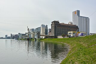
Deutsch: Mühlenufer entlang des Industriehafens (Hafen 41) auf der Friesenheimer Insel, Mannheim - von rechts Hildebrandmühlen, Club Kraftfutterwerke, Mühle der GEG, Pfalzmühlen, Bunge (ehemals VDO)
English: Mills along Industry Harbor (harbor 41), Friesenheim Island (Friesenheimer Insel), Mannheim, Germany |
| Date | |
| Source | Own work |
| Author | Hubert Berberich (HubiB) |
| Permission (Reusing this file) |
Author: Hubert Berberich |
| Camera location | | View this and other nearby images on: OpenStreetMap |
|---|
Licensing
[edit]
This file is licensed under the Creative Commons Attribution 3.0 Unported license.
- You are free:
- to share – to copy, distribute and transmit the work
- to remix – to adapt the work
- Under the following conditions:
- attribution – You must give appropriate credit, provide a link to the license, and indicate if changes were made. You may do so in any reasonable manner, but not in any way that suggests the licensor endorses you or your use.
File history
Click on a date/time to view the file as it appeared at that time.
| Date/Time | Thumbnail | Dimensions | User | Comment | |
|---|---|---|---|---|---|
| current | 17:21, 3 April 2015 | | 4,496 × 3,000 (2.7 MB) | HubiB (talk | contribs) | == {{int:filedesc}} == {{Information |Description = {{de|Mühlenufer entlang des Industriehafens (Hafen 41) auf der Friesenheimer Insel, Mannheim - von rechts Hildebrandmühlen, Club Kraftfutterwerke, Mühle der GEG, Pfalzmühlen, Bunge (ehemals VDO)}}... |
You cannot overwrite this file.
File usage on Commons
There are no pages that use this file.
File usage on other wikis
The following other wikis use this file:
- Usage on de.wikipedia.org