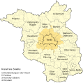
File:Karte Metropolregion Berlin-Brandenburg.svg

Original file (SVG file, nominally 829 × 833 pixels, file size: 327 KB)
Captions
Captions
Summary
[edit]| DescriptionKarte Metropolregion Berlin-Brandenburg.svg |
Deutsch: Metropolregion Berlin-Brandenburg (in hellgelb), engerer Metropolenraum/Kernraum (Agglomeration bzw. „Speckgürtel“ in dunkelgelb |
| Date | (UTC) |
| Source |
This file was derived from: Metropolregion-BerlinBrandenburg-Infrastruktur.svg |
| Author |
|
Licensing
[edit]- You are free:
- to share – to copy, distribute and transmit the work
- to remix – to adapt the work
- Under the following conditions:
- attribution – You must give appropriate credit, provide a link to the license, and indicate if changes were made. You may do so in any reasonable manner, but not in any way that suggests the licensor endorses you or your use.
- share alike – If you remix, transform, or build upon the material, you must distribute your contributions under the same or compatible license as the original.
Original upload log
[edit]This image is a derivative work of the following images:
- File:Metropolregion-BerlinBrandenburg-Infrastruktur.svg licensed with Cc-by-sa-3.0,2.5,2.0,1.0, GFDL
- 2010-04-05T18:46:25Z Broadway 825x826 (913709 Bytes) Hintergrund
- 2010-04-05T17:38:41Z Broadway 825x826 (976010 Bytes) {{Information |Description={{de|1=Infrastruktur der Metropolregion Berlin-Brndenburg}} {{en|1=Infrastructure of Berlin-Brandenburg, Germany}} |Source=self-made, using [[:Image:Landkreise Brandenburg.svg|Landkreise Brandenburg
File history
Click on a date/time to view the file as it appeared at that time.
| Date/Time | Thumbnail | Dimensions | User | Comment | |
|---|---|---|---|---|---|
| current | 22:55, 15 November 2020 |  | 829 × 833 (327 KB) | Dingens5 (talk | contribs) | Kfz-Kennzeichen statt Zahl für kreisfreie Städte |
| 18:21, 27 February 2013 |  | 829 × 833 (322 KB) | NordNordWest (talk | contribs) | c | |
| 13:19, 16 December 2012 |  | 829 × 833 (495 KB) | NordNordWest (talk | contribs) | == {{int:filedesc}} == {{Information |Description={{de|1=Metropolregion Berlin-Brandenburg (in hellgelb), engerer Metropolenraum/Kernraum in dunkelgelb}} |Source={{Derived from|Metropolregion-BerlinBrandenburg-Infrastruktur.svg}} * http://gl.berlin-bra... |
You cannot overwrite this file.
File usage on Commons
There are no pages that use this file.
File usage on other wikis
The following other wikis use this file:
- Usage on de.wikipedia.org
- Hauptstadtregion Berlin-Brandenburg
- Liste der Hallenkirchen in Deutschland
- Agglomeration Berlin
- Wikipedia:Kartenwerkstatt/Archiv/2012-12
- Wikipedia:Auskunft/Archiv/2017/Woche 30
- Geografie Berlins
- Liste der Bauwerke der norddeutschen und rheinischen Backsteingotik in Deutschland
- Benutzer:Ulamm/Positionskartenlimit
- Benutzer:Z thomas/BB-0
- Usage on diq.wikipedia.org
- Usage on es.wikipedia.org
- Usage on frr.wikipedia.org
- Usage on fr.wikipedia.org
- Usage on it.wikipedia.org
- Usage on www.wikidata.org
- Usage on zh.wikipedia.org
Metadata
This file contains additional information such as Exif metadata which may have been added by the digital camera, scanner, or software program used to create or digitize it. If the file has been modified from its original state, some details such as the timestamp may not fully reflect those of the original file. The timestamp is only as accurate as the clock in the camera, and it may be completely wrong.
| Width | 828.738px |
|---|---|
| Height | 832.906px |