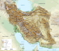
File:Iran-geographic map.svg

Original file (SVG file, nominally 3,013 × 2,600 pixels, file size: 12.78 MB)
Captions
Captions
Summary
[edit]| DescriptionIran-geographic map.svg |
English: Geographic map of Iran. Limits of the map:
|
||
| Date | |||
| Source |
Own work
|
||
| Author | Ikonact | ||
| Permission (Reusing this file) |
Any use of this map is subject of the license(s) stated below with the condition that you credit (Wikimedia Commons user: Ikonact) as the author . A message with a reply address would also be greatly appreciated. | ||
| SVG development InfoField |
|
Licensing
[edit]
|
This work contains information from OpenStreetMap, which is made available under the Open Database License (ODbL).
The ODbL does not require any particular license for maps produced from ODbL data. Prior to 1 August 2020, map tiles produced by the OpenStreetMap Foundation were licensed under the CC-BY-SA-2.0 license. Maps produced by other people may be subject to other licences.Open Database LicenseODbLhttp://opendatacommons.org/licenses/odbl/1.0/true |
- You are free:
- to share – to copy, distribute and transmit the work
- to remix – to adapt the work
- Under the following conditions:
- attribution – You must give appropriate credit, provide a link to the license, and indicate if changes were made. You may do so in any reasonable manner, but not in any way that suggests the licensor endorses you or your use.
- share alike – If you remix, transform, or build upon the material, you must distribute your contributions under the same or compatible license as the original.
Assessment
[edit]
|
File history
Click on a date/time to view the file as it appeared at that time.
| Date/Time | Thumbnail | Dimensions | User | Comment | |
|---|---|---|---|---|---|
| 17:25, 20 September 2023 |  | 3,013 × 2,600 (12.69 MB) | Socialdilema (talk | contribs) | File uploaded using svgtranslate tool (https://svgtranslate.toolforge.org/). Added translation for ca. | |
| 17:22, 20 September 2023 |  | 3,013 × 2,600 (12.68 MB) | Socialdilema (talk | contribs) | File uploaded using svgtranslate tool (https://svgtranslate.toolforge.org/). Added translation for ca. | |
| 14:08, 8 May 2020 |  | 3,013 × 2,600 (12.62 MB) | Yamaha5 (talk | contribs) | File uploaded using svgtranslate tool (https://tools.wmflabs.org/svgtranslate/). Added translation for fa. | |
| 20:44, 1 May 2020 |  | 3,013 × 2,600 (12.62 MB) | Ikonact (talk | contribs) | + hidden Text: MW workaround for displaying translations | |
| 20:43, 1 May 2020 |  | 3,013 × 2,600 (12.62 MB) | Ikonact (talk | contribs) | + hidden Text: MW workaround for displaying translations | |
| 20:39, 1 May 2020 |  | 3,013 × 2,600 (12.62 MB) | Ikonact (talk | contribs) | File uploaded using svgtranslate tool (https://tools.wmflabs.org/svgtranslate/). Added translation for bg. | |
| 20:01, 1 May 2020 |  | 3,013 × 2,600 (12.55 MB) | Ikonact (talk | contribs) | + hidden Text: MW workaround for displaying translations | |
| 21:49, 30 April 2020 |  | 3,013 × 2,600 (12.55 MB) | Ahmad252 (talk | contribs) | File uploaded using svgtranslate tool (https://tools.wmflabs.org/svgtranslate/). Added translation for fa. | |
| 21:10, 30 April 2020 |  | 3,013 × 2,600 (13.24 MB) | Ikonact (talk | contribs) | + legend | |
| 21:19, 28 April 2020 |  | 3,013 × 2,600 (13.18 MB) | Ikonact (talk | contribs) | == {{int:filedesc}} == {{Information |description= {{en|1=Geographic map of Iran. Limits of the map:}} *N: 40.229° N *S: 24.327° N *W: 42.517° E *E: 64.314° E Equidistant Cylindrical projection; WGS 84 datum |date=2020-04-28 |source={{own}} *Sources of data:<br/> **Topography: ETOPO1 (public domain);<br/> **Other data: © OpenStreetMap contributors;<br/> *Tool:<br/> **The map is created with Octave scripts developed by Ikonact |author=Ikonact |per... |
You cannot overwrite this file.
File usage on Commons
The following 3 pages use this file:
File usage on other wikis
The following other wikis use this file:
- Usage on ar.wikipedia.org
- Usage on ast.wikipedia.org
- Usage on avk.wikipedia.org
- Usage on az.wikipedia.org
- Usage on bg.wikipedia.org
- Usage on bn.wikipedia.org
- Usage on ca.wikipedia.org
- Usage on ckb.wikipedia.org
- Usage on cs.wikipedia.org
- Usage on da.wikipedia.org
- Usage on diq.wikipedia.org
- Usage on el.wikipedia.org
- Usage on en.wikipedia.org
- Usage on eo.wikipedia.org
- Usage on eu.wikipedia.org
- Usage on fa.wikipedia.org
- جغرافیای ایران
- کاربر:Alieseraj
- توپوگرافی
- کاربر:مام وطن
- کاربر:Basp1
- کاربر:جعبه کاربر/مدافع خاک ایران
- کاربر:Gshahali
- بحث کاربر:Zzvf
- کاربر:Hamid Hassani
- کاربر:Derakhshan
- کاربر:Wiki center
- ویکیپدیا:گزیدن نگاره برگزیده/مه-۲۰۲۰
- کاربر:Arian.ramin
- ویکیپدیا:قهوهخانه/فنی/بایگانی ۶۵
- ویکیپدیا:گزیدن نگاره برگزیده/Iran-geographic map.svg
- کاربر:Adel2020
- ویکیپدیا:نگاره روز/اوت ۲۰۲۲
- کاربر:Amdanesh
- کاربر:Adolfzl64
View more global usage of this file.
Metadata
This file contains additional information such as Exif metadata which may have been added by the digital camera, scanner, or software program used to create or digitize it. If the file has been modified from its original state, some details such as the timestamp may not fully reflect those of the original file. The timestamp is only as accurate as the clock in the camera, and it may be completely wrong.
| Width | 3013 |
|---|---|
| Height | 2600 |